SEA CHANGE: On the evening of October 29th, 2012, Hurricane Sandy struck the coastal communities of New York and New Jersey, inflicting devastating damage upon buildings, infrastructure and land forms alike. In the process, the event exposed the vulnerabilities of a range of low-lying areas and made it clear that construction and development in these environments would never be the same. As the rebuilding process begins, projects such as the one proposed for Arverne East in the Rockaways must rethink the traditionally employed models of design and construction that no longer address the current realities of coastal conditions. The solution to establishing a new paradigm for smart development in the face of such vulnerabilities begins with the restoration of ecological balance and propriety within the site, the establishment of a comprehensive storm management and recovery strategy, and the integration of a platform-based construction typology that lifts residential spaces safely above base flood elevations. A single, versatile system that strikes a balance between these environmental, social, economic and aesthetic concerns is within reach.
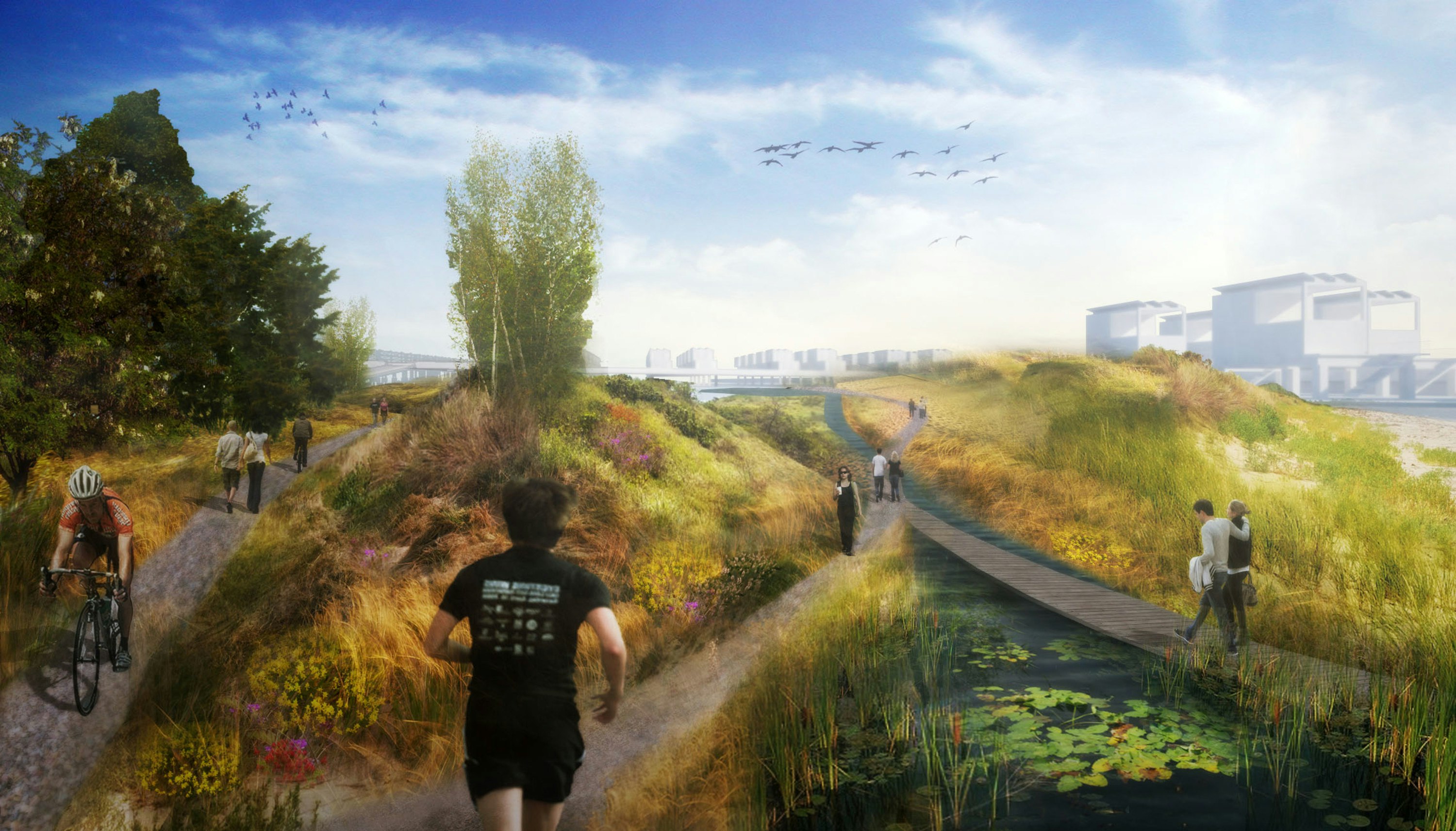
ACHIEVING BALANCE: Long before the Arverne East site was ravaged by Sandy, much of what was once the rolling landscape of coastal bungalow communities that included Arverne and Edgemere were leveled by bulldozers as part of the City’s attempts at urban renewal in the Rockaways during the 1960’s. Today, there remain but a few functional dunes while the rest of the parcel is undergoing varying degrees of coastal plain and forest successions that feature both native species and invasive exotics. A geomorphological review of the site reveals that the parcel’s eastern end, approximately a third of the beachfront, remains particularly vulnerable due to the coastal processes that conspire to scour away the sand, sediment and dune systems that previously protected inland spaces. In that area, the depth of the beach will be tripled in size in order to restore balance to that environment, dunes will be restored and created, and a seawall in the form of a substantial sheet-pile bulkhead will be installed 50’ north of the section of boardwalk destroyed by Sandy.

The landscape will be reestablished with inspiration drawn from Long Island’s many coastal ecologies and features, including dune systems, bluff formations, coastal plain, forest and wetland communities--with a highly diverse suite of appropriate coastal species woven throughout the entire site. The site will feature both ecological and dune preserves while the pathways through the residential and commercial areas will double as conduits for storm water that will also be filtered through beds of wetland vegetation and bioswales, The flora that will be integrated throughout the site will provide visual appeal throughout the seasons while serving to stabilize ground conditions and provide food and habitat for a wide range of wildlife.

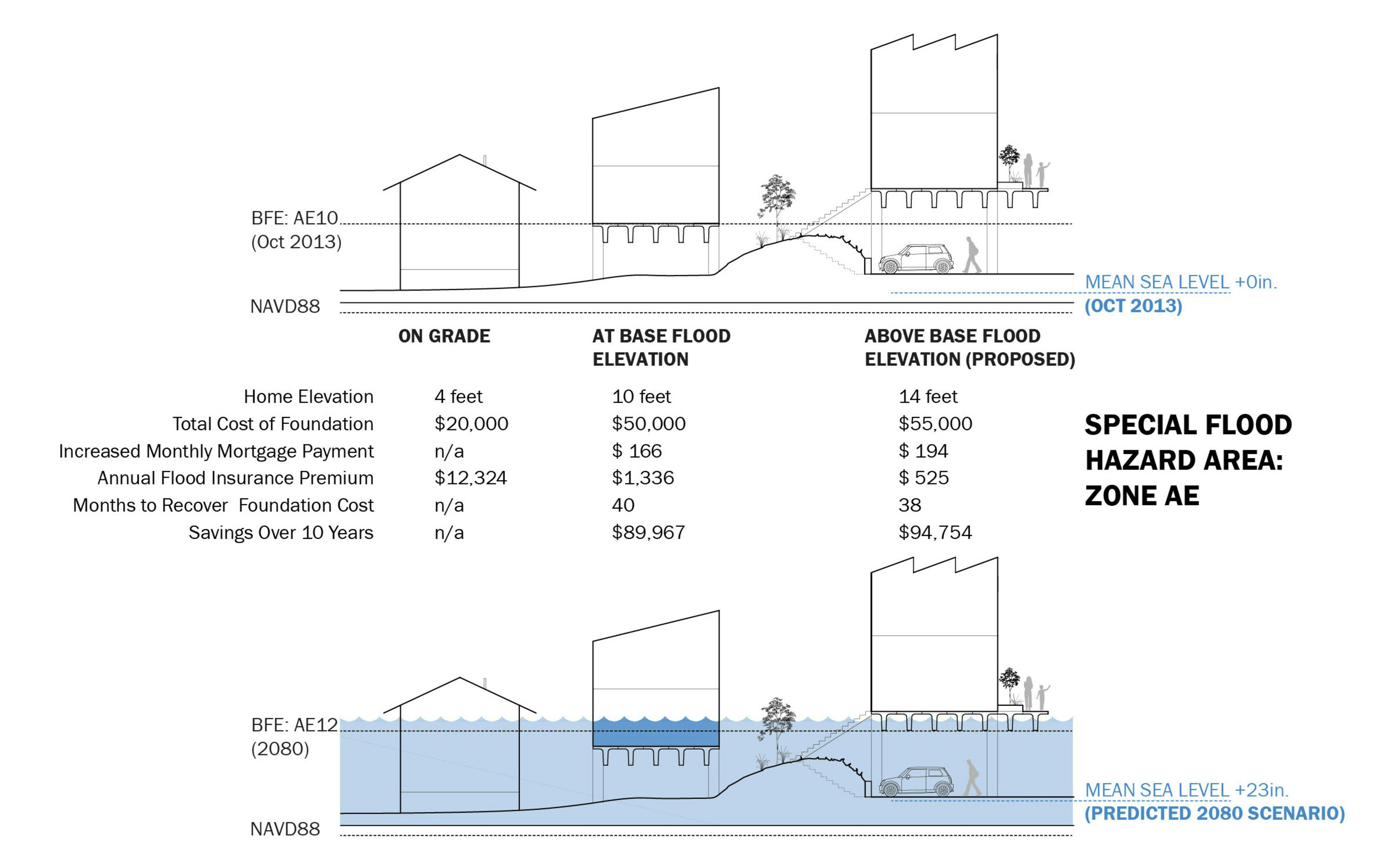
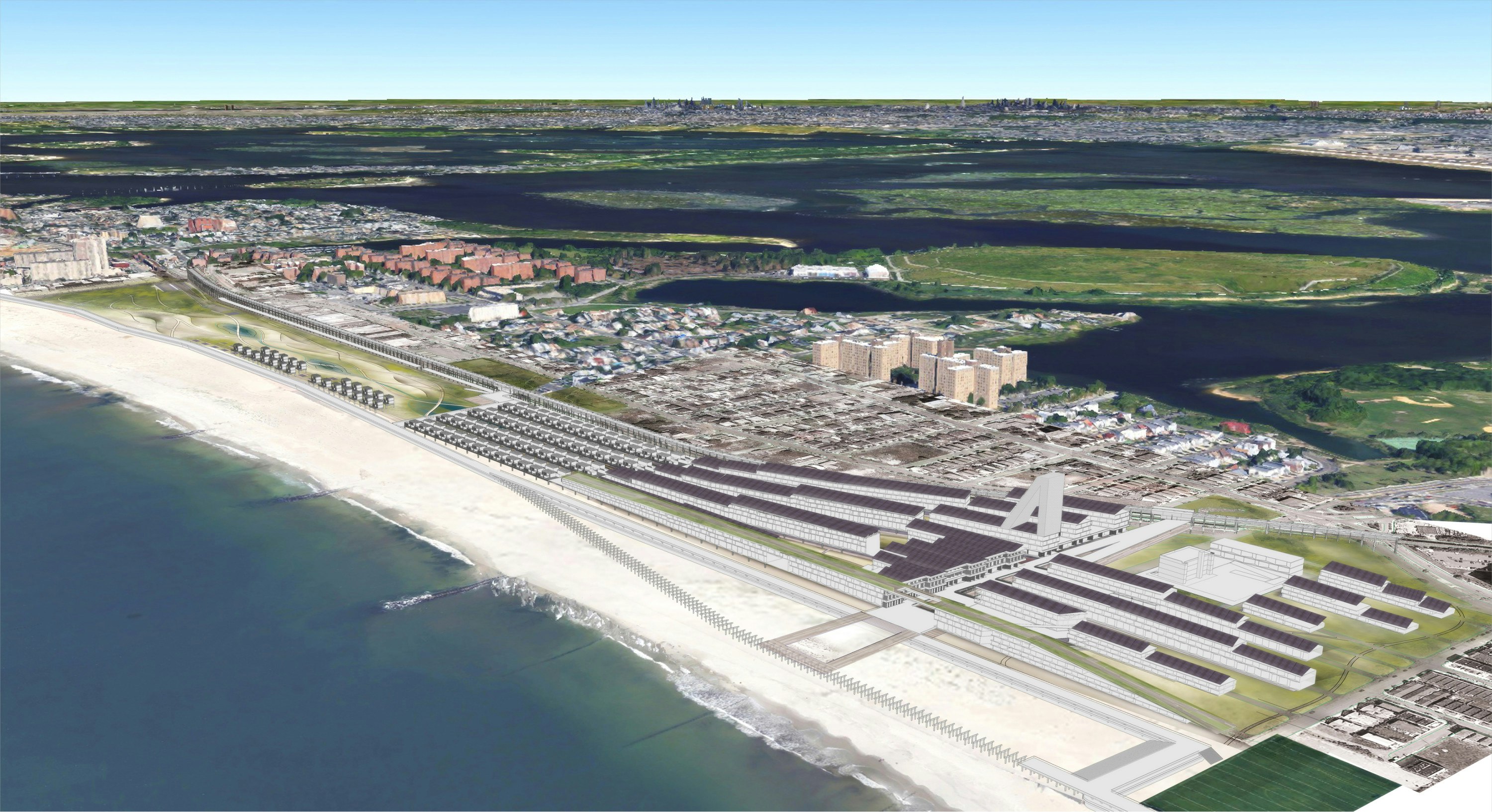
BRIDGE TO A SUCCESSFUL COMMUNITY: The continuation of residency in low-lying coastal areas requires a move upwards in concert with a sensitive landscape strategy beneath. The concept of platform construction is not a new one for New Yorkers surrounded by examples of elevated life throughout the network of buildings, bridges, subways and parks that facilitate urban life. Precast concrete extruded forms--the simplest and most economical structural system available--will be used to bridge the Arverne site to existing adjacent neighborhoods to and through two separate subway stops, while providing both residents and neighbors access to the beach, shopping, jobs and recreation. Locally prefabricated housing units will be erected atop these platforms, with infrastructure anchored underneath them. All buildings are located an optimal 4’ above the current FEMA base flood elevation (10‘-0” above the NAVD 88 datum) providing for additional height to address future climate change and sea level impacts as well as minimizing flood insurance and construction costs.
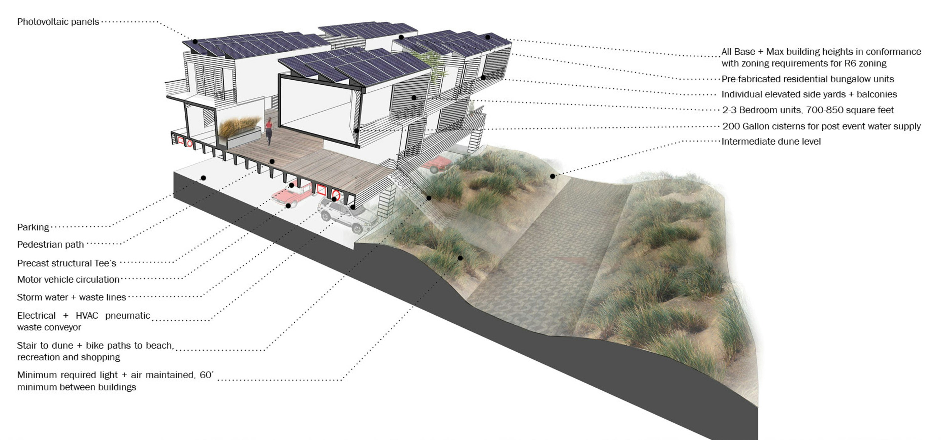
LIVE, WORK, LEARN, PLAY, VISIT...LIVE WELL: This design calls for multiple types of residential units: 3-story Dune buildings; 2-story Stacked Bungalows; and 2-story single family Beach Bungalows. All of the residences will feature strong connections to the site via balconies, elevated yards, direct access to the pedestrian and bike paths, and all will reference the historical typology of the site in a more contemporary and ultimately more sustainable manner.
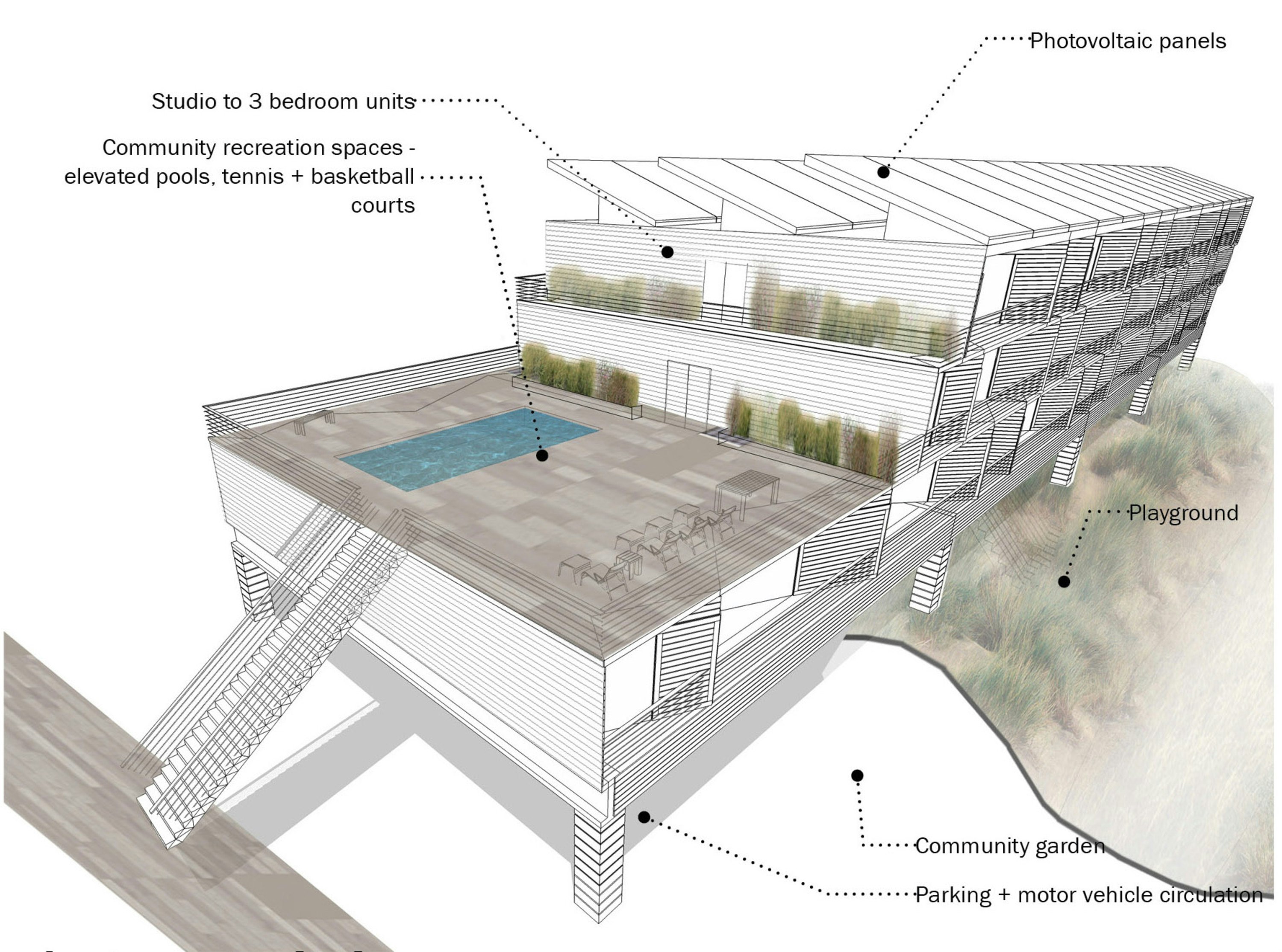
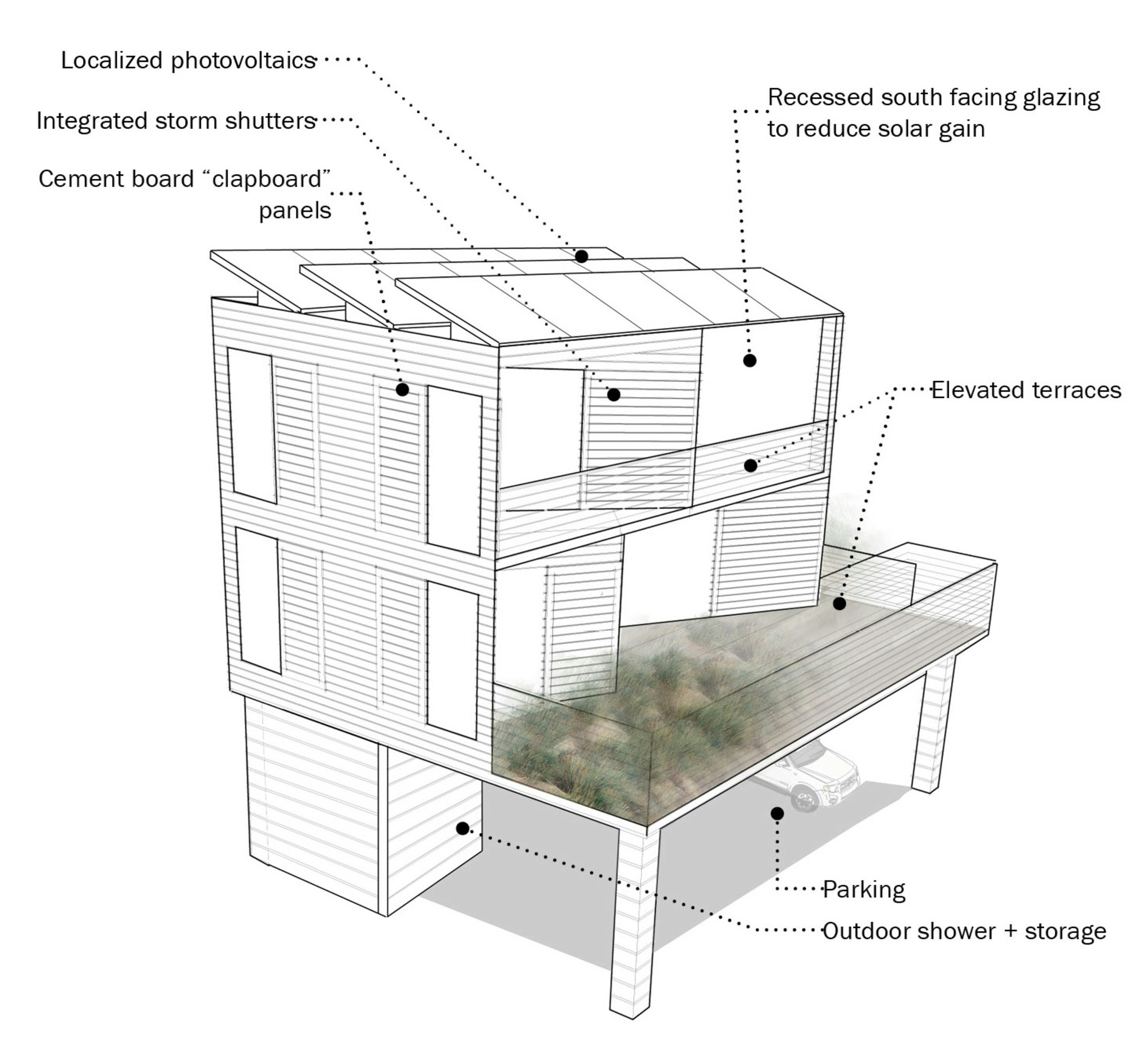
The types transition gradually from the greatest density multi-family buildings in the mixed use zone to the east of the site towards the single family houses that lay on the periphery of the preserve to the west. The architecture will correct the past half century of inappropriate materials and massing prevalent in the Rockaways, scaling down from high rise apartment buildings to 2- to 3-story dwellings atop platforms, composed of inexpensive, attractive and resilient materials, framing a more dignified and geographically appropriate lifestyle.

The easternmost portion of the site will be dedicated to the densest mixed-use development; large scale retail starting at the north and gradually shifting scales along a central plaza to smaller scale restaurants and entertainment programming by the beach and boardwalk.
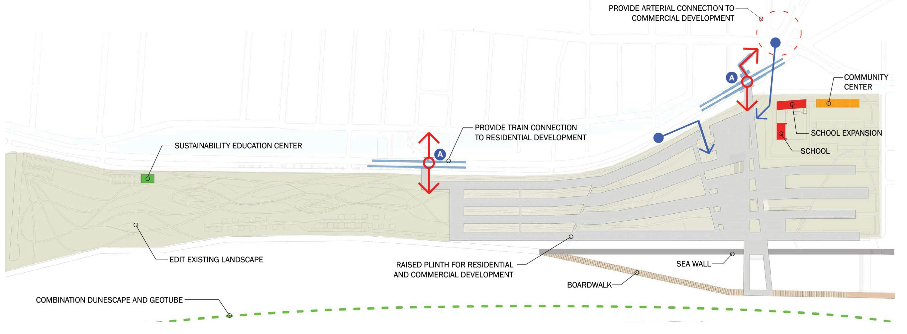
Above, retail will be commercial offices and a terraced hotel with views of the ocean. A central observation tower and green bridge are accessible from the central plaza, elevating visitors above the site to help them better understand the site and the challenges it faces. A small pier extends from the plaza to engage the ruins of the boardwalk destroyed by Sandy in remembrance of the Hurricane’s devastation.
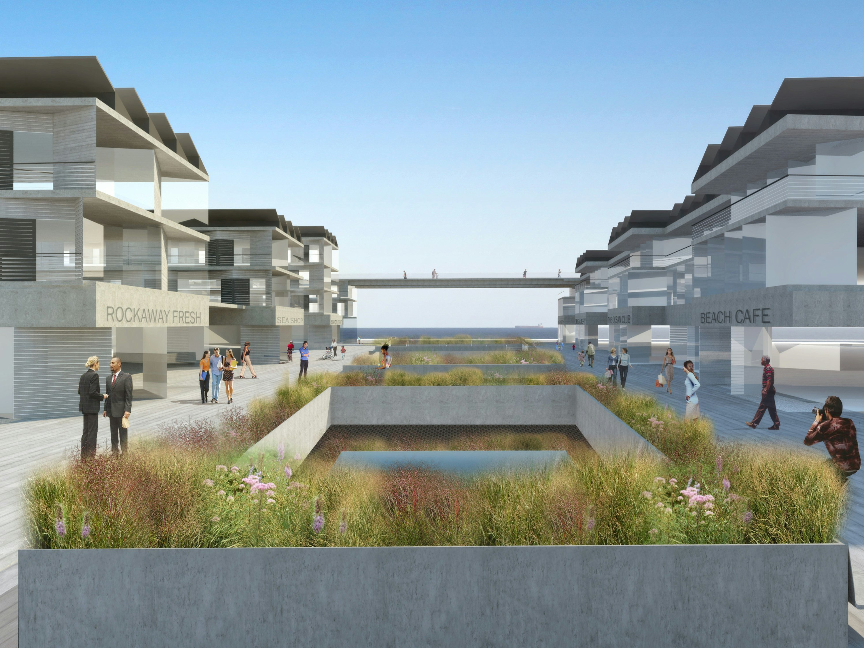
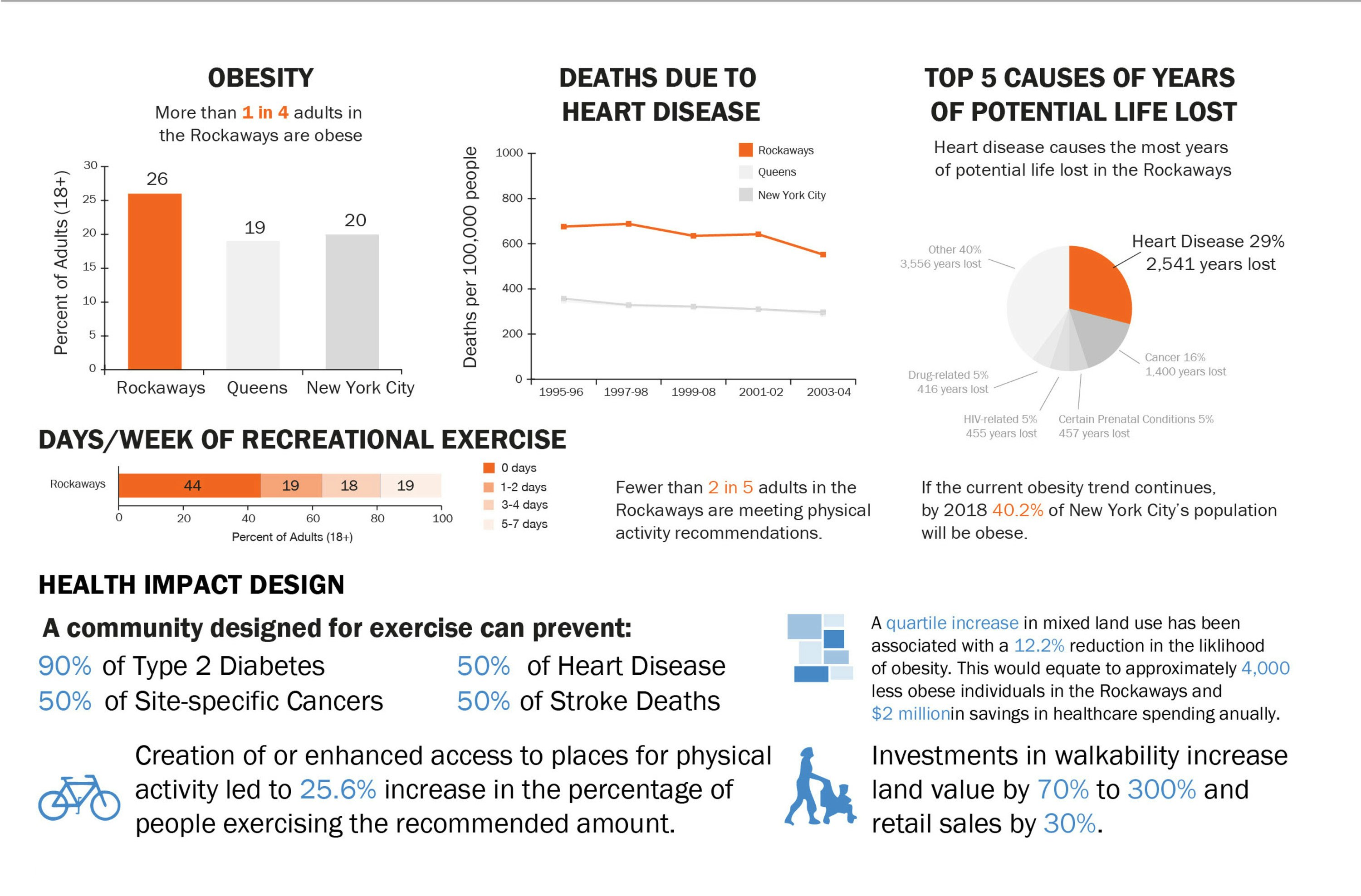
Circulation through Arverne East will occur on multiple levels, with cars and delivery trucks circulating and parking below the elevated platforms while pedestrians and cyclists will move freely through the site via a gamut of natural paths, elevated platforms and boardwalks. This arrangement yields significant social benefits by providing a barrier-free circulation system, improved pedestrian safety and increased opportunities for social interaction--all while increasing efficiencies. This network connects a series of active and passive recreation areas to the residential and commercial components of Arverne East, encouraging exercise and boosting fitness for residents and helping to mitigate a number of health issues endemic to the area. The diversity of recreational opportunities, coupled with the commercial array will help draw visitors from the city and beyond and boost the local economy.
Introducing such a sizable development will require upgrades to the existing infrastructure and a meaningful effort to positively impact the surrounding neighborhoods. P.S. 106 will be expanded to include a raised additional structure that replaces the K-through-2nd grade building destroyed by the storm while accommodating the additional students that will arrive with an expanded neighborhood, with parking for teachers moved beneath the structure, restoring full use of the playground to the students. A community center will be located nearby and utilities will be fortified to make them less susceptible to damage from extreme wind or flooding. Minimal amounts of electricity will be consumed during winter months while a fair amount of it will be produced in the summer. Streets will be reconfigured for improved flow and ample parking will be provided for the retail, residential and beach visitor areas beneath the network of overhead structures.

REGENERATION GENERATION: Arverne East will utilize a number of high performance systems to establish a net positive energy profile. Residential unit layouts will be efficiently designed, reducing the typical footprint and the energy required to build, operate and maintain them while offering maximum integration potential for renewable energy technologies. Small scale passive strategies such as external shading, a high performance envelope, aggressive daylighting and natural ventilation will be utilized in tandem with high efficiency active systems that include lighting, Energy Star appliances and ground source water-to-air heat pumps. This synergy between different design elements will be capitalized by installing integrated photovoltaic panels that will generate and sell back more electricity to the grid in a year than the project will consume. The entire system is scalable and easily adaptable to anticipated developments in hydrogen and desalination technologies in the long term, with a shift away from fossil fuels towards electricity generated by cleaner sources in the short term.
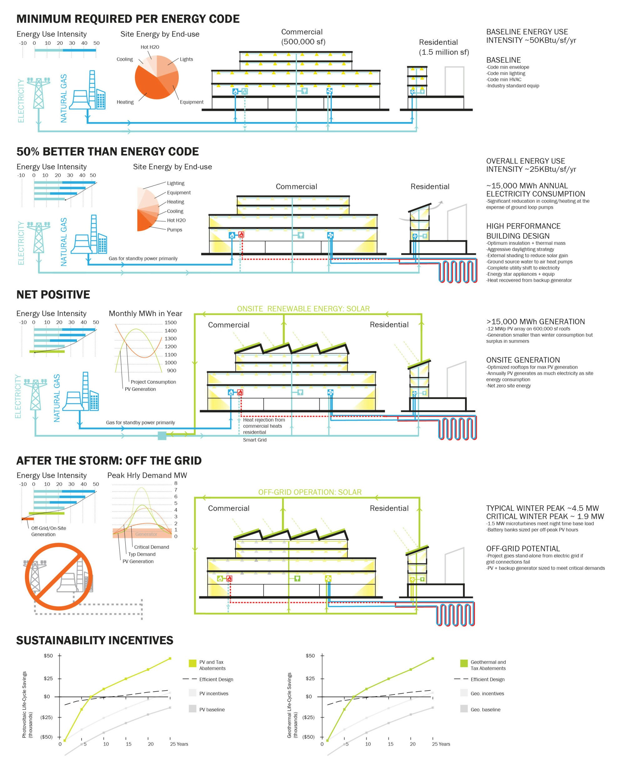
RESILIENCY AND RECOVERY: While it is unlikely that another event exactly like Sandy will occur, it is an inevitability that the continuation of sea level rise, which scientists anticipate will increase by two feet or more by 2050 in the area, combined with the processes of beach evolution and the impacts of hurricanes and other storms, will challenge any development built at Arverne East. When such an event severs municipally provided utilities, the on-site renewable generation strategy backed up with an alternate fuel powered co-generation plant will enable the community to go completely off-grid, serving critical loads for the duration of the recovery period.
Water conservation measures will be imposed to limit the amount of water used and wastewater generated during a storm event when connections to municipal water/water utilities are compromised. Each residential unit will be outfitted with a cistern capable of holding enough water for a family of 4 up to 4 days. Similarly, sewage will be collected in an onsite tank for the same period should the municipal system be non-functional, with agreements in place to periodically remove the stored sewage by vendors in such an event. Should multiple days pass without transportation and city services, residents will not be trapped in their homes and will have basic services maintained while they retain use of the elevated paths and plazas.
THE PATH AHEAD: Hurricane Sandy marks the end of coastal development as we know it. The cost of the devastation incurred in lost lives, property and opportunity were too great to continue in the same vein. A wholesale rethinking of the way we live along the coast is due. This reconsideration presents us with an opportunity to improve upon the model, balancing the lowest possible impact on both the land we restore and develop and the resources we use to do so, with the highest possible benefit to the health, well being and prosperity of those that reside there. The following proposal is smart development that is capable of changing communities, is scalable and could serve as a model for seaside communities everywhere.
FARROC Team
DXA studio: Architecture
Atelier Ten: Environmental Design
Patrick Cullina Horticultural Design + Consulting: Landscape Design
Archive Global: Public Health Policy
ARUP: Infrastructure Engineering, Masterplanning, Hydrology & MEP Engineering
Robert Silman Associates: Structural Engineering


